If you’ve seen me recently, you might have noticed a new gadget dangling from by belt: a GPS receiver, which can be used to locate your position on earth. You might be tempted to ask: what the heck? (which would actually be a sensible question). The simple answer would be: “I am mapping the world.”
OpenStreetMap (OSM) is a cool project that works collectively towards that goal. People collect GPS tracks by walking/cycling/driving around, use an editor to enter that information and voila, maps are returned. (The UK, especially the London area, is pretty well covered if you want to browse around)
Why is that necessary, would be the next (sensible) question. There are Google Maps, Yahoo Maps, Maquest, Mapblaster, the Ordnance Survey and hundreds of other sources which you can use for free. One answer would be: Those sources are not really free. It is illegal to copy their maps on your cool shiny Nokia N800 and use it as a portable navigation device. It is not possible to create your own routing software with that data. And you can’t change the layout or design of the maps or tinker in hundred other ways with the data. All this is possible with the OSM data which is available under a Creative Commons License.
The second answer is: because it is fun. It is interesting to explore areas you’ve never been before although they are close to where you live. You discover interesting streets/buildings/shops. You get to find shortcuts for routes that you have been using for months. You get an excuse to walk and bike a lot more than you previously did, which also feels good. And you get that warm fuzzy feeling when you see the map and say: see, I mapped a part where only white area had been. It makes you feel like Columbus and Capitan Kirk at the same time.
ZDnet has a nice introductionary article on the project, which you might be interested in.
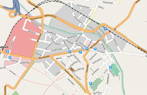
This is how my town Dübendorf currently looks like.